Sunday, September 26, 2010

Alamosa, CO, to Espanola, NM

We departed Alamosa and rode the flat and rather featureless 28 miles to Antonito, CO, where we had lunch in a non-descript park. Well, some freshly-laid grass and kids playground equipment, along with a few hard plastic seats and tables. Everything around this was dust and dirt.

We then headed west along highway 17 towards Chama, New Mexico. We were planning to get to a campground just inside Rio Grande National Forest, although after reaching the small town of Mogote, seven miles later, we found a very well-run private campground (Mogote Meadows). After 35 miles we had had enough, and the stop allowed Alia to do some work (they had WiFi) and have her regular Monday meeting. And, yes, I got to watch the NFL prime time game.

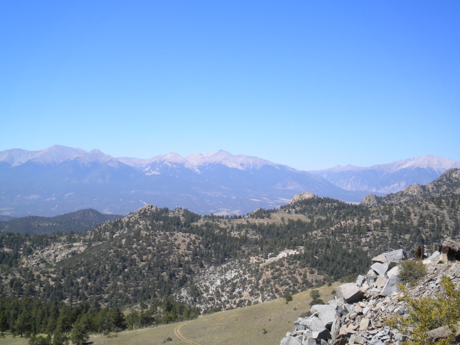
Highway 17 (pictured, left) is part of the Caminos Los Antiguos, which as you may recall we had been travelling along earlier in the San Luis Valley. From our guide we understood this particular section of the trail was one of the most spectacular bits of pavement in the entire southwest U.S. It didn't disappoint. From the featureless environs just east of Mogote we gradually twisted and turned our way into another stunning valley framed by sheer rock ledges and filled with the heavy yellows of numerous aspen groves. We rejoined the Great Divide Trail at the small town of Horca (we had been off the official trail for six days), at which point the road headed for the heavens - from around 8800ft just west of Horca to 10230ft in 5.5 miles at La Manga Pass, all at 5 per cent grade (or more at times). Throw in a short but sharp thunderstorm along the way (we jumped into a glade of pine trees and pulled the tarp over our head for this) and it was a challenge. The view over the Conejos (Rabbit) Valley, home to various peoples for 8000 years, was surreal. It reminded me of the Megalong Valley in the Blue Mountains near Sydney.

We camped for the night just off the highway, deep in amongst the pine trees at just under 10000ft in altitude. The night was brisk. Four cows in the next grove of trees kept us company, their eyes reflecting back at us each time we pointed our torches in their direction. For some reason we got a real kick out of this. Cows. They make us laugh, whether they're fleeing from us as we approach them on a remote dirt road (for no apparent reason, and usually at the very last moment so you're never sure of which direction they'll head), or just galloping up towards us in order to simply stare at the people on the bikes. Maybe their blank stares aren't symbolic of their lowly stature in the food chain but instead of a genuine concern for our mental health, the weird people on the bikes. Moo.

We had originally planned to head to Chama, in the U.S. state of New Mexico, entirely along pavement. That would mean leaving the Great Divide Trail again, and this time for quite a while. At the turnoff though we changed our minds. The day looked grand, and the offroad trail invited us into yet another aspen-filled valley. So, we left Highway 17 and turned south on Co. Road 117 (CO) and 87 (NM). We knew the dirt/gravel roads in New Mexico were tougher than anyway we had been but we still didn't quite fathom how bad they would get. We entered New Mexico a few miles after leaving the highway and the road surface rapidly deteriorated, from just a rough gravel road to nothing more than a rock-strewn path. And all up some sheer grades; at one point we had to push our bikes for over a mile up to the top of Brazos Ridge, not a pleasant task over rocks you could build a house with.

I do wonder at times why the trail takes us on roads that would otherwise be best left alone. Yes, these very roads more often than not take us to remote places with wonderful vistas. Yet I just can't imagine some of the people I've seen on the trail enjoying these stretches, none least than myself. Back to that fine line between pleasure and pain. You feel weak for seeking to avoid some of these stretches although you simply don't enjoy trudging up yet another bloody goat track - the Great Divide does have a few pavement-based alternative routes within New Mexico, largely due to how bad rain can affect these sections, and I would suggest they should do another one around this part. At least travelling along these alternates you feel like you're not cheating, that you're still part of the 'official' trail.

Rant over, on with the journey.

I feel like I'm getting a tad monotonous describing each new view we encounter. It's difficult describing some of them, they are just that big and grand, so far beyond the human scale. This particular vista was even more special as we could see as far as the section of the Sangre de Christo mountains that backed the Great Sand Dunes National Park, what I would estimate was 60-70 miles away, along with much of the San Luis Valley. Immediately in front of us though was the Cruces Basin Wilderness, a relatively compact valley again generously blessed with the sublime colours of Fall.

After topping out at 11000ft, we spent the afternoon making up time on better surfaces, gliding through think stands of aspen and open fields. Our goal was to get as close to Highway 285 as we expected rain the next day. And rain means impassable roads in these parts, even for high-clearance 4WDs. We ended up rough camping near the Rio San Antonio that evening, a night graced with a cloudless sky and an almost full moon lighting the landscape. The next morning we were greeted with the ominous sight of deep grey crowds moving in from the southwest, not a good sign. We again left the official route and made for Highway 285, which links Antonito (yes, we had almost completed a full circle through the mountains) with Tres Piedres, NM, a 'town' 25 miles away that had the usual collection of depressingly empty and boarded-up shops and gas station. We arrived just before a torrent of water descended from above; we ended up eating our lunch inside the local Post Office. Yet if we thought we had beaten the weather, we were severely wrong. We still had to ride another 31 miles to Ojo Caliente in the south, and we really had no choice - that was our only option for somewhere to stay for the night.

Three miles out from town, and down came the water. Well, not just down, but horizontally...in it came, a fire hose directed straight at us, the people on the bikes. It was hard at times to simply look up, the rain stinging our eyes and faces. On we went, luckily at a good pace due to the relatively flat mesa terrain we were on. Certainly not a preferred experience, instead just another unique set of circumstances we found ourselves in again, one we strangely accepted with a smile on our face for most of the way. We eventually descended into Ojo Caliente at around 4pm, although while the rain eased it was soon back to its soaking best just at the time we went to set up our tent at the excuse of an RV Park at Ojo Caliente Hot Springs Resort. Mud everywhere, a restroom complex that was actually just a couple of toilet-paper deprived and dirty Portaloos, and no shelter whatsoever. This for $23 a night. And all next to the decadent five-star resort that owned the place. Shame Ojo Caliente, shame! I did eventually get some money back after complaining but even then I had to push the manager - he kept agreeing with everything I said but would then just go silent...meaning I had to say I don't just want his words but something more tangible for the poor facilities. Like, MONEY YOU FOOL.

Our Macpac tent held up well considering, with just a bit water seeping in at the time we put it up. Condensation was our worst enemy, a light layer of water coating most things we owned. The next morning's sunshine certainly made us feel a lot better, allowing us to dry out all our wet weather gear and the tent, amongst other items. We spread our gear over three empty sites in an attempt to get as much sun as possible on our gear; three hours later and we were relatively dry again - until we hopped into the very hot pools we had sought out in the first place. Set against a small cliff face were a series of hotpools; two had arsenic in them, another iron, and another soda. All incredibly relaxing, and all welcomed after the previous day's exertions.

That afternoon we descended yet further through another valley to the town of Espanola, 25 miles south. There really isn't much to say about this town, except that it has a few characters that you wouldn't want to meet in a floodlit alley let along a dark one. As one resident we met described the town, it's ghetto man, ghetto. But it serves our purposes well. We're well and truly off the Great Divide trail now - it heads west through the towns of El Rito, Abiquiu and Cuba, and onto Grants. We plan instead to head south to Bandalier National Monument tomorrow (Monday Sept 27), and then travel along what is meant to be another spectacular roadway, that of highway 4 to Albuquerque via San Ysidro and Bernalillo. I expect we'll meet up with the Great Divide trail again in El Malpais National Monument, to the west of Albuquerque. That's after a McMullen becomes a Parker.

Until then, take care, and thanks for all of your best wishes on our impending nuptials.

Saturday, September 18, 2010

Salida, CO, to Alamosa, CO

Our first day's ride from Salida would not be forgotten by either of us. Not so much for the scenery this time, as good as it was heading up 10,842ft Marshall Pass. No, this time it was about Alia and I, and our future together. Yes, it was time to ask 'that' question - no, not whether we could buy a house next to Villa Park and buy a lifetime club membership. Or what was for lunch (and what time should we eat. Soon?).

No, it was time for the really big question.

It took me a while to get things planned but I managed to get it all together. The moment took place after we reached Marshall Pass, around 26 mostly tough uphill miles from Salida. Earlier that day, just outside Poncha Springs, we met Ed from northern California. He would get almost as much of a shock as Alia would once we reached the pass. After setting our bikes against a wooden sign at the top, I reached into my front bag and pulled out the ring; I walked over, handed Ed my camera (which has a video), knelt down and asked Alia if she would be my bike partner for life. She said yes, and I was thrilled. And we could honestly say it would be all downhill from that point - quite literally, as it was a three mile drop to our campsite for the night. It was an enjoyable descent (aren't they all), not least due to events at the top - adding to the ride was the sharp yellows of the aspens that lined much of the route.

Next morning we made the 10 miles to the small town of Sargents, a town on highway 50, where we enjoyed a cooked breakfast. Any time we ride through a town we generally try and take advantage of the local diner or restaurant, most of which cook up pretty good breakfasts and burgers, amongst many other things. And coffee. Lots of coffee. Please.

People have been curious about what we eat. If we're out on the trail, it's generally a breakfast consisting of a granola or bran cereal topped with prunes (don't they get me going) using milk powder,along with a coffee provided we have enough gas remaining (and I don't mean from the prunes) in our canister; lunch consists of sandwiches, usually with dried meats and cheese (the type that doesn't need to be refrigerated, with the happy cow on it. Moo.); dinners are usually pasta and/or rice based, along with mash potato as a starter (the potato comes in powder form, to which you just add hot water). Snacks include high-energy protein bars, Mars or Snickers bars, and plenty of trail mix. The longest period we generally have to pack food for is four days, although even on these stretches can come across some form of small general store or diner. In some ways water is the harder item to plan for and pack. We usually know where water can be found, as our maps are quite detailed. Yet at times we still need to carry 7-8 litres, as it takes time and batteries to filter and clean any water we consume from rivers or streams (we have an ultraviolet filter). And with one litre of water weighing around 1 kilogram (2.2 pounds), you can quickly see how weight can then become an issue - you really do feel it when you're cycling up the side of mountain.

Back on the trail from Sargents, we made our way along highway 50 until we turned south onto a dirt road that traversed a semi-desolate valley. The Elk Mountains, young and proud, beckoned to the west. After a total of 48 miles for the day we reached Dome Reservoir where we camped for our second night since leaving Salida. Ed was still with us, and he was great company - we appreciated having someone with us who was not only interesting in his own right (Ed is very much an outdoors person) but whose shared riding experience gave us a fresh perspective on the same trail we had traversed. Ask any rider and they love hearing about how others fared on the route, particularly the tougher sections - so it was no surprise that the Great Basin back in Wyoming featured prominently.


Our next day, 41 miles from Dome Reservoir to Storm King Campground to the southeast, would have us riding up two 10,000-plus passes (Cochetopa and Carnero). And, as only Murphy would have it, the second one was the much tougher one, just at the time late in the day when you've spent most of your energy.

The changing colours of the many aspen groves continued to captivate. Not just yellows but also oranges and reds burst through the otherwise largely green canvass. As we descended into the lower altitudes we rode through a number of wonderfully contorted and tight canyons, some with rock formations so life-like you found yourself staring at them while descending at 15-20 miles per hour on rough roads. And all savoured with no one else around, something that was noticeable on this third day.

From Storm King campground we made our way through another staggering rock formation, the grand basalt entrance to Coolbroth Canyon. Quite simply, wow. We stopped before it, beneath it, and after it...we just had to see this mass of rock from every angle possible. Our next stop, La Garita, little more than a general store/diner, saw us enjoy a burger and beer before we headed across the very flat and seemingly arid (well, not so as it would turn out) San Luis Valley. On the opposite side of this Valley was our next stop, the Great Sand Dunes National Park. We parted ways with Ed here - he continued south on the trail proper. His company would be missed.

We pointed our wheels east towards the distant Sangre de Christo mountains, sheer 14000ft peaks that sit as a stunning backdrop to the National Park. Maybe it was travelling on flat and paved roads again, and the extra ground you can travel, but our (well, ah, my) estimates of how long it would take us to get to the National Park were severely wrong. What I guessed would be a fairly easy 30 mile ride ended up being 45 miles and that only yielded us a campsite at San Luis Lakes State Park, still 12 miles short of the National Park (but a wonderful campsite all the same, as it looked over the sand dunes). Add to this the 15 miles we had travelled earlier in the day, and you have a total of 60 miles, or 100km. What made things a bit tougher was a poor choice of route by yours truly which saw us mired on a road so sandy that we had to walk a mile to the north to get to the nearest paved road, plus the unexpectedly high temperatures (we later learned that the San Luis Valley, at 8000ft, is a magnet for the sun, the best place for collecting solar power in the entire country. In a twist to this though, it's a haven for growing crops such as potatoes and carrots, as it sits upon a huge aquifier).

It was all well worth it. The Great Sand Dunes were absolutely amazing, billions of grains of sand so flowing and sculptured you swear a human hand had spent an eternity crafting them. We climbed the second highest dune in the park, at around 700ft, giving us a vista so magnificent I won't even bother to try and describe it. Suffice to say, get there yourself one day. That these dunes are backed by yet another stunning mountain range, that of the Sangre de Christo (Blood of Christ), only added to the spectacle. We camped just outside the park that evening, at Oasis Campground and Lodge, and while a privately run facility we found ourselves in a rugged and secluded site amongst gnarled pinon pines with seemingly endless views across the Park and San Luis Valley. Coyotes howled us to sleep again that evening, and not long before the sun flooded the valley once more we heard the 'who who-whos' of an owl. It's easy to understand why the Spanish left this as the northern border of their Americas territory, it's sheer remoteness and toughness still so easy to imagine and feel to this day. That, and the marauding Ute Indians, who were so effective on horseback at defending this region that no permanent settlement was made by white man in the area until the 1850s.

Our next day had us ride 33 miles to the town of Alamosa along what was the best bits of pavement we have cycled the entire trip, road 150 (part of the scenic byway named Los Caminos Antiguos, or Trail of the Ancients), and highway 160. The latter had a shoulder so large it really belonged on Arnold Schwarzenegger - no girly-man shoulder for this part of the country. At 2-3 metres wide we had plenty of room to move on what is a rather busy road.

Our next two weeks will see us enter New Mexico, and make our way to Albuquerque (again, off the official trail). To date we've cycled over 4000km, or 2600 or so miles. From there we'll take a week off and head to Vegas for our wedding, before returning and starting on the trail again. Until then, all the best.

Thursday, September 9, 2010

Kremmling, CO, to Salida, CO

From Kremmling, Alia and I headed south towards Silverthorne; by the end of the day we churned out 57 miles after our preferred campsite, at Blue River, was closed (the second one we had come to in Colorado that was closed). With only another 12 miles to Silverthorne, and three more after that to the next campsite at Heaton Bay, all on pavement, we decided to push on (we really had no choice). Luckily, we had enough time to do so - it was only 5.30pm.

The day itself had been fairly steady, with around eight miles of uphills including a solid four miles up 9153 ft Ute Pass, at around 6 per cent grade (we were ascending from a base of over 8000 ft, so not too bad). Certainly, the view from the top of Ute Pass along with the thrilling descent at 30 miles per hour (48 km/hr) on fairly new paved road made it more than worthwhile. As we motored down we gawked upon the Eagle Nest Wilderness (pictured), which included some staggeringly beautiful and rugged peaks.


The only negative was the behaviour of some (most) drivers on one (Co. Rd 3) of the gravel backroads leading to Ute Pass. Being Labour Day weekend, it was busy, so we understood the higher level of traffic - but to drive past two cyclists at speeds in excess of 50 miles an hour, rocks flying in our direction, wasn't too courteous. We even got the impression some sped up as they passed us. So at odds with Coloradans in general, whom had been so welcoming and hospitable to date.

Silverthorne is largely a Factory Outlet centre, complete with all the key brands. Good thing it was after closing time. And that was for me, not necessarily Alia. I do love my shopping, the result of some weird gene in my male body. Sale signs captivate; add to that Factory Outlet and you have my undivided attention. The entire city sits beneath the wall of Dillon Reservoir, one of Denver's water sources. The wall is quite a sight, towering above the buildings below.

We ended up cycling in the dark that night as we decided to eat dinner in Silverthorne. There are some nights we just can't fathom the idea of cooking yet more pasta or rice. The darkness made it a tad tough although we have fairly strong lights on our bikes, and (unusually) we were following a bike path the entire way. This 20 mile or so long path, which links Silverthorne with Breckenridge, was testament to the saying, 'Build it, and they will come'. The next day, admittedly the Sunday of a long weekend, saw hundreds of people out and about on the trail. You couldn't overtake on some sections, it was so choked with cyclists, walkers and parents pushing prams. So refreshing to see in the car-crazed U.S. (not that someone from Australia can really talk).

From Silverthorne, we dodged the cafe-lattes in Frisco and Breckenridge (OK, so we had one ourselves. Darling, we had too - both towns are laden with nice homes and snug eateries and cafes), and began our ascent of our highest pass to date - 11,480ft Boreas. Expect the worst and hope for the best they say - spot on in this case. The ride up was actually quite pleasant. Yes, really. After all, it was on a former railway line bed, and as such the climb was generally steady and sedate on an at-most four per cent grade. Still, we felt elated upon making the top (see Alia, pictured, as she makes it), the second highest point on the entire Great Divide trail. The former railway, which operated from 1884 to 1937, was a spur to Leadville from the main Denver line, and was largely used to transport the various minerals that were being mined in the area.


The small town of Como (pictured in the distance), named by the Italians that once worked on the railway, greeted at the end of what was a 39 mile day. And so did a couple of rather tasty Indian Pale Ale pints and a meal at the local pub/B&B. The proprietor, from London, England, allowed us to camp next to his fine establishment that cold and windy night. Our tent battled against some violent wind gusts throughout the night; at some points in the evening the tent, one specifically designed to handle the wind (it's a tunnel tent), barely struggled to stay upright.


The next day was no better. Whilst the first five miles had us moving with the wind at our back - Alia said she hurtled along at 40km/hr without pedalling - the next three saw us battle what had become an aggressive sidewind. We estimated wind gusts hit 40-50 miles per hour. Alia actually came off her bike at one stage (luckily she managed to jump off just as the bike keeled over). Walking through what was another barren landscape, one flanked with granite-encrusted mountains to either side of us, was our only option. With another 20 or so miles to the next town, our thoughts became rather grim. Just how far would we need to push? The wind continued to whip against us, hurting our ears and forcing us to stop at times in order to stop our bikes falling. My Touret's spurted forth once again (as in space though, in a howling wind no one can hear you. I can certainly testify to that).

Mercifully, we crested a rise and the road edged eastward again, giving us a tailwind once more. The scenery remained consistent throughout much of the day. We were in dry, dusty valley floors flanked by tree-covered mountains - it was almost as if everything green clung for dear life to the edges of the dry abyss we were forced to traverse. There were plenty of houses along the way, some staggeringly large and inviting (no matter how long we lingered out the front of these properties, no one would come out and invite us in for the evening...damn), most strategically placed amongst the very few rocky outcrops and clumps of trees there were. Property prices weren't too bad, particularly just south of Hartsel - $9950 for 5 acres. What a steal, or so we thought - until we learnt from a local that on whatever plots were being sold there were no natural impediments, not even a single tree, to the winds we had just fought against, plus it laboured under the weight of a winter that commonly yields 15ft of snow. Maybe not the investment hotspot we envisioned.

After 50 miles we found an illegal campsite just off the road; it was a cold night, one we were eager to get through. We both were very much looking forward to getting to the next town, a mere 25 miles away, of Salida. Between us and our three-day rest was the pass adjacent to Cameron Mountain, and views towards the majestic Collegiate Peaks (named after the key US universities, including Yale, Harvard and Princeton - see adjacent picture). All over 14000ft, they demanded your attention - unfortunately, so too did the road beneath us. Nothing too bad but with enough sharp turns and bumps to keep your eyes south of your tires.

As we had eaten breakfast that same morning a lone coyote had ventured within 50 yards of us. He would stop. Then scamper another 10 yards towards us. Stop. Scamper. Stop. Scamper. As he peered towards us I thought of Kevin Costner in Dances with Wolves; would this coyote, like Costner's Wolf, come close and dance with me? Before I could size up my potential dance partner his movement halted - by the sound of a car, one of only two to pass us since the night before. Off he scampered over the grasslands, headed for the hills. There would be no dancing with this coyote.

And so we made it to the lovely town of Salida, a town that has survived the onslaught of modernity with class and style. House styles are mixed, from art deco through to turn of the 20th century, yet all share an owner's meticulous care. With the Labour Day weekend over, so too are the holidays that kept many tourists out and about. I'm not sure how busy Salida becomes each summer, although with its wide, tree-lined streets and generous sidewalks, something tells me it retains a relaxed air throughout the busy season. That many come here seeking the great outdoors, that is, seeking nature over commerce, only adds to its laidback charms. It's a wonderful place to put the feet up.

Before I sign off please go to YouTube to view some very basic videos (from my camera) I have uploaded, one of which includes part of the rapid 2500ft descent into Salida. The other is from Yellowstone, and our Buffalo encounter. You can see these by using either of these links (you can't search for them otherwise): http://http//www.youtube.com/watch?v=YF_bj9Rd3jI AND http://http//www.youtube.com/watch?v=jLsXdtwXhBU


Our next phase will have travel through southern Colorado, and should include a visit to the Great Sand Dunes National Park.

Friday, September 3, 2010

Pinedale, WY, to Kremmling, CO

Greetings from another hotel room, this time located in northern Colorado. It's been another week or two full of highs, of challenges, of headwinds and tailwinds, of mountain passes (and more bloody passes), and of coyotes howling at our tent door.

You may recall we were bracing for one of the most remote sections of the trail, the Great Basin in southwest Wyoming. Essentially it's terrain not dissimilar to a desert, where water is scarce. Very scarce. We began from Pinedale, well rested and engaged in the task ahead. The first 25 miles or so had us on a fairly flat grade of pavement, always a treat to this cyclotourist. The Wind Ranges gradually faded the further east we travelled.

Our tires then touched the dirt; and it was dirt and sagebrush for much of the next 200 miles. Our goal that day was Little Sandy Creek, an informal campsite next to a fairly reliable stream. History was never far from our wheels. At one point, as our surroundings became increasingly spartan and remote, we crossed Buckskin Crossing, or more accurately the Big Sandy River. This was part of the trail many trappers, fur traders and emigrants used in the 1800s when crossing from the eastern US to the west. Throughout this part of Wyoming we criss-crossed many a trail of yesteryear, from the Mormon Trail through to the Oregon and California Trails. It's difficult to comprehend how tough it must have been travelling by horse and cart through this part of the country all those years ago; bikes are luxuries in this context.

After completing our 49 miles from Pinedale to Little Sandy Creek (pictured at sunset), we met a cowboy the next morning who looked after thousands of acres and the 2200 head of cattle that roamed them (forget fences, these are free range cattle). Amongst other topics, I mentioned how glad I was we were finally out of Grizzly bear territory (Pinedale is as far south as they range); he mentioned how cattle owners would budget for a 20 per cent loss of stock due to Grizzlies and, perhaps surprisingly to us, wolves (from the same batch inserted into Yellowstone, hundreds of miles away). He wasn't too complementary of the Grizzly population in particular, citing days where he would come across five Grizzlies on his travels. "We should just be allowed to shoot them, you know, just in the arse, not to kill them, but to ensure they know to associate pain with humans."


Our next day has us visiting South Pass City and Atlantic City, the last vestiges of civilisation before heading across the Great Basin. South Pass City (pictured) is now a preserved historic site, one based on its heyday when it was a gold-producing locale that attracted people from all over. We enjoyed an ice cream and Gatorade from the one and only General Store as we pondered our next legs, through the Great Basin.

The heat wasn't too bad at this stage, although some of the hills around South Pass and Atlantic City were tough, so much so we were often off our bikes and pushing uphill. The roads were of good quality though, hard-packed dirt and gravel that allowed for easy and reliable rolling. Nothing worse than having worked your butt off to get to the top of a mountain only to find the descent is marred by a road full of ruts and rocks, making for a slow and often dangerous ride.

From Atlantic City, a town a hundreds, we entered the long barren stretch towards Rawlins, WY. Our guide book suggested camping next to Sweetwater River, which was 10 miles from Atlantic. This would force us to travel 69 miles the next day, with just two water sources along the way - the first 11 miles from Sweetwater River (Diagnus Well) and the other located at the end of the day's ride (A&M Reservoir). I wasn't enamoured with this plan so, with the road quality good and the wind at our back, we decided to push onto Diagnus Well that evening.

We were glad we made this decision although, as we were to learn, it wasn't an easy ride. The next 11 miles were on roads more akin to rough tracks, and sand was a constant danger, as I learnt not once, but twice. Both times my bike hit heavy sand my front wheel basically stopped, and off I went...ironically, the very substance that instigated the fall made for a relatively soft landing. Alia had a similar experience but managed to stay upright. Just, she said. It took us over two hours to do the 11 miles, and after a search for the 'Well' - in this case just a lone pipe pumping out water from deep beneath the Basin (for animals and humans alike) - we made camp just before sunset after travelling a staggering 61 tough miles. We can be quite quick setting up camp (see picture - this was taken the next morning) and getting dinner prepared - around 30-40 minutes - but we couldn't be quick enough to beat the setting sun. It was quite the feeling, camping on an open plain with little more then sagebrush and sand as companions. Oh, and whatever that was that scratched around the edge of our tent that evening. The sky was clear, something I look forward to more and more as I get to know the constellations of the northern hemisphere.

I'm glad we pushed on that evening, as the next day was our toughest. After filling up with water (FYI, we purchased a three-litre Camel Back pack that sits on the rear of Alia's bike; it's insulated which is extremely helpful in hot weather. All up, we were carrying this plus another 4.5 or so litres in a combination of four bike bottles and a 1 litre pack. Just enough as it would turn out).

Up and down we went; the road remained heavily rutted and sandy for the first 10-15 miles of the day, and only then did it harden up and make for more 'pleasant' cycling. We pushed hard until lunch, at which point we had completed 30 miles. Out came the tarp, and we sat amongst the sagebrush looking east towards the uranium mine at Green Mountain, a name that must have been an easy choice considering the trees that covered most of it, a stark contrast to the brown sun-baked plains stretching from its base. A strong westerly was blowing us toward our destination; hard to imagine having to ride into a wind on a day like this.

So much of today's riding, for me at least, was mental. The actual riding was on relatively flat terrain, so that wasn't the issue. It's more the distance and the lack of water. On days like this one I often have to remind myself to look up and around at the scenery as I can tend to solely focus on the ground ahead. Keeping a rhythm is also critical, as is setting short-term goals. A snack mid-afternoon, for example, becomes something to look forward to. Again, perhaps I'm sounding negative. I honestly don't mean to when I share the pragmatics our ride. Alia is certainly more accepting of the challenges we face; I tend to spit the dummy at some point each and every day. Alia thinks I may have turret's syndrome. FXXXX. Really? No, I'm just another Parker, one who struggles with pressure and gets emotional rather quickly. OK, very quickly. FXXXX. Full credit to Alia though, she pedals along largely without complaint. Well, perhaps the odd complaint. About me and my short temper.

A&M Reservoir looked like an oasis when we finally pulled in there, 57 miles from Diagnus Well. Much of the water for this reservoir was being pumped up from below, creating a water source of perhaps 100 metres by 50 metres. Proghorns were sipping at its edges as we set up camp on its shoreline. I was in for a swim in no time at all, and after filtering the water we had a good drink and our usual dinner fare, mashed potatoes for starter followed by a pasta (or rice) dish. After settling into our tent for the night we were treated to our very first encounter with coyotes; it was late in the evening when Alia shot up in her sleeping bag. We had just listened to the howls and yip yipping of a pack of coyotes not too far from us. What got Alia's attention though was the moon shadow of one coyote immediately adjacent to our tent. Like, next to Alia's head. Silence. Some padded steps circle us. More silence. Howling from the distance. The silence lengthens. After some more time, an eternity perhaps, we semi-relax. The coyote is gone. Sleep comes fitfully.

Our final day on this remote stretch is relatively easy, with the majority of the 57 miles to Rawlins on pavement and highway. What hit us a bit harder than expected was the shifting winds as we crossed the Continental Divide just outside Rawlins. The winds shifted sharply and rapidly, with tailwinds becoming dangerous crosswinds in a flash. Crosswinds may not sound so bad except for the panniers we have on the rear of our bikes (but thankfully not on the front) - these give the winds some surface to play with. And don't they enjoy playing with us, hitting us from the east and west at irregular intervals. Not much fun when you're travelling on a 65-mile an hour highway (although one that thankfully had a generous shoulder for cyclists, something Wyoming excels in).
Rawlins was once the home of Calamity Jane, and she spent some time in the local jail there. We holed up in a cheap motel there for the night, catching up on some cleaning, eating and drinking. Our next stretch caught us a bit by surprise; I expected a relatively easy 48 mile ride to the next campground. Instead, we were hit by 25 mile-an-hour headwinds across another spartan (yet entrancing) landscape. We had been warned about the winds of Wyoming, and here they were in all their fury. Edging along at 5 miles an hour wasn't great fun. Neither was the sharp gradient up 7900ft Middlewood Hill. We managed to get to another open yet informal campsite at 40 miles (when I say informal, you can legal camp in many places along our route, unless posted otherwise. Our maps also indicate many informal campsites, many located near water sources as this one was), and yet again we settled into our sleeping bags against the backdrop of coyotes howling in the near vicinity. I had since learned they weren't considered a dangerous animal. But their howls can suggest otherwise, at least to this soft Aussie. A somewhat comforting thought was this would be our last day on the open plains of Wyoming - we would enter Colorado tomorrow. And whilst mountains and steep climbs beckoned, being surrounded by trees would at least (partly) shield us from winds.

And so it panned out. Entering Medicine Bow National Forest, we were immediately blanketed with thick forest, much of it the white aspen that would follow us through into Colorado later that day. Stands of aspen (see photo) give the otherwise green slopes dominated by conifers some depth and variety. Their leaves flutter in the wind, so much so you swear you're hearing a raging torrent of water. We hit highway 70, still in Wyoming, and it isn't long before we see the mountains of Colorado to the south (see picture below). I had forgotten how captivating distant mountain peaks can be. We head southwest along highway 70 before taking a sharp turn to the east along road 710 (which becomes road 129 in Colorado, four miles later). We wind along the Little Snake River, past increasingly lavish ranches, including Three Forks Ranch, which is owned (I later learn) by the owner of the Arizona Cardinals NFL team. Lavish is an understatement. I could have putted on their pastures, they were so well manicured. Alas, putting wasn't on the forefront of my mind - getting up and over the 8700 feet pass just before Columbine was. And that night, if possible.


We pushed and pushed. Quite literally in fact, getting off our bikes regularly to get up yet another wall of road. We didn't make it. Falling a few miles short wasn't the end of the world, or so we thought at least. We found a camping spot in Routt National Forest, out in an open field and near one single tree. A creek curved a 100 yards beneath us, and the impressive granite capped top of Hahn Peak sat to our south. Some hunters camped beneath some trees near us came over; we chatted about the lack of Bull Elk in the area (they can hunt them for two weeks each year). The sun had set, and we were ready for bed. Just as I was heading into the tent, I noticed an increasing amount of lightning to the west. Not a good sign, as most of the bad weather in this part of the world came from that direction. I rechecked our tent's lines, reset and tightened a few, and went to bed. Nothing much happened after that; the wind gusted a few times but nothing too serious.


It was later that evening though that all hell broke loose. The thunder woke me, but it was the sharp and intense flashes of lightning that grabbed my attention. Closer and closer is came. The wind intensified. Our tent was coping admirably. But with the lightning literally flashing all around us at this point, and the thunder (and storm) now above us, I wasn't coping so well. We lay prostrate on the ground, me praying for this storm to pass. The lightening was surrounding us; it lit up the tent a few times. I pulled the sleeping bag tighter around my neck, as if this would protect me. Go away, go away, was all I could think. That I'm writing this now tells you it did, but we have learned about where best to set up tent since that night - always under trees, and preferably nearest the smallest one of a large and tall bunch (the lightning will generally go for the largest tree). Thankfully we didn't camp next to the stream, as water is one of the best conductors of electricity there is. Anyway, lesson learned.

The next day saw us crawl our way up the pass and into the delightful confines of the Columbine Cabins general store, and a warm coffee. After yet more rain, which we waited out, we headed south through Hahn Village and Clark, rolling into Steamboat Springs, a skiing mecca, later that afternoon. We camped there for two days, spending our well-earned rest day hunting for new (rear) bike tires (which we fond - Michelin's), oil and groceries. Steamboat Springs wasn't as touristy as we expected; very laid back, bike friendly, and with a free shuttle bus that runs the length of town, starting literally metres from our campsite (about 1.5 miles west of town). We enjoyed our first sit down meal here, a great big steak that we cooked ourselves, and an all-you-eat salad buffet. Was it really rude to go back for thirds? Mmm, something to ponder as I loaded my plate up again.

From Steamboat we headed almost directly south, camping about 7 miles short of 8900 ft Lynx Pass. Again, we had planned to get to a camping site at the Pass but an unexpected detour which added four miles to our route undermined our efforts (a dam crossing was closed due to construction, meaning a circuit of Stagecoach Reservoir). This detour though did allow us to meet Chuck - what a great, great American name - and his wife, who only too readily restocked us with water for the final 15 miles of our ride that day. Chuck (I was tempted to ask him when Missing in Action 51 was due to come out - he did look a bit like Mr Norris) was synonymous with what people had told us about Coloradans. They are outdoors people, they are friendly, and they are only too happy to help. The trails are busier here, full of people doing active things. Are we really still in the US?

And, so, from just south of Lynx Pass, which we summit the next day (Sept 2), we eventually made our way to Kremmling, 34 miles away. We detoured off one part of the official Great Divide trail, one particularly onerous segment that would taken us down 2000ft in the space of a few miles towards Radium, only to then climb back at least half of that late in the same day. No thanks. We stood there for five minutes debating our decision - the road down was apparently OK but complete with sharp turns and some rocks. And some of the scenery was meant to be staggering. Yet mentally we weren't quite prepared for another dose of off-road mountaineering, which is what some of this ride often entails, so we instead ascended 9500ft Gore Pass (about two miles up from where we were), a relatively easy ascent considering it was on pavement. From there was coasted down another 11 miles of highway, hitting Highway 40 six miles north of where we are now.

Kremmling is a small town, one perfect for a lazy day doing our washing and catching up on things like blogs and watching movies. Yes, sounds shallow. But it's amazing how the body and mind just shuts down at times and fights against any sort of stimulus - whether mental or physical - or any kind. Or is that just me and my puny mind? Something to think about. But I can't, just not now, as Lara Croft and Tomb Raider is on....From here we'll head south to Salida, a town we hear many a good thing about. We plan to rest there for three days before heading on to the Great Sands National Park, and possibly Mesa Verde National Park (both of which are off our trail but very enticing). Some rather large mountain passes await to the south including a monster of 12000ft. Ouch.

But that's for later. Now, what's on after Lara Croft...?

Distance update - we've done 2249 miles todate, or 3600km, over 60 days of (actual) cycling. And who has the yellow jersey? Well, team Parker-McMullen isn't that competitive. But having a podium, champagne and some French models (male and female of course) at the end of each stage would be quite a motivator, wouldn't it?!?